Sanborn Insurance Maps - an Overlooked Genealogical Resource
What the Sanborn Insurance maps are and how they can be helpful
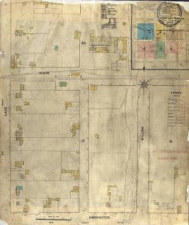
The Sanborn Company began making fire insurance maps in 1867 when founded by Daniel Alfred Sanborn, a surveyor from Somerville, Massachusetts. From 1867 to 2007, the company mapped about 12,000 populated urban areas in the United States. These maps show the location of all the major buildings and are color coded for type of construction. The maps are valuable for establishing the location and identity of older buildings in the communities covered by the maps. Surprisingly, the maps show many of the smaller communities, such as the map of American Fork, Utah made in 1890 shown below.
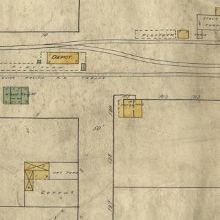
Here is a larger view of the same map:
Many of these maps have been digitized and are available in different mapping programs. You may have to search a little to find a digitized map of the area where your ancestors lived. In many cases the maps can help identify old buildings shown in photographs and may give valuable clues as to the churches and businesses in the area where you are searching for your ancestors.
Quoting from Wikipedia: Sanborn Maps,
Author Kim Keister describes the legacy of Sanborn maps: "Stated simply, the Sanborn maps survive as a guide to American urbanization that is unrivaled by other cartography and, for that matter, by few documentary resources of any kind."[1] They are a highly useful resource for historical research, planning, preservation, genealogical research, sociological studies and research of urban geography.
More information about where the Sanborn maps can be located are found in the Sanborn Maps article on Wikipedia.
Written by James L. Tanner. Used with permission.
Need help finding more records? We have genealogy research services available. You can also try our genealogical records directory which has more than 1.3 million sources to help you more easily locate the available records.
Related Topics
- Learning Genealogy Articles more than 140 helpful articles to help you to do genealogy more effectively
- Keys to Finding Relevant Genealogical Sources Some general rules on where to look for record sources
- Using Distances and Travel Time Between Places in Genealogy Research Using the time period and distance between places for better accuracy
- About Migration Patterns in Genealogy Research How putting your ancestors in a historical context can help you understand their migration patterns